 (February 3, 2017) Day 4 of 17 of my ride to the San Francisco Bay Area and then north along the Pacific coast to Bellevue, Washington took place on Monday, June 13, 2016. I got up around 5:45 a.m. and departed from El Reno, Oklahoma about 6:30 a.m. The sky seemed clear in the morning twilight, so I dressed for warm, dry weather. That didn't last. I checked the weather the previous night and the forecast looked good. I should have checked the weather radar in the morning. Live and learn.
Photo above right: That's me at in Cimarron Canyon State Park along US 64 in northen New Mexico. (Latitude 36.5375 Longitude -105.1524)
I encountered severe weather only about 20 miles west of El Reno, and because the sky was so grey, it was hard to tell until the last minute that I was entering a major thunderstorm. All of sudden there was lightning and high winds--in addition to the heavy rain. I pulled over under a bridge to get out of the wind. My friends will tell you that if I pulled under a bridge, it must have been bad.
I also discovered that I had forgotten to pack my helmet with a faceshield! I had somehow managed to pack two open-face helmets. Even with all of my careful preparation, I still managed to make a major packing blunder! Fortunately, I had packed my high-tech balaclava, which served me well.
Forced to pull under a bridge east of Elk City, Oklahoma
I was already soaked to my skin, but I put on my rain suit anyway, for warmth if nothing else. The lightning was so spectacular, I pulled out my iPhone and captured some video. That morning ride in the rain lasted well into Texas, more than 100 miles. It soaked my wallet, which I put in what I thought was in a water-resistant pocket in my rain jacket. No! I'm unhappy with my Aerostitch Darien riding suit as far as rain protection goes. Maybe it's gotten too old. Anyway, the 20 or so $100, $20, etc. bills I had in my wallet were soaked. I had to spread them out on my hotel bed to dry. The leather wallet itself and the other contents faired better--wet early but dried quickly.
Because of the severe weather in the morning, I went to Plan B on the route: I stayed on I-40 all the way to Amarillo and then got on US 87 north. I did this because I could barely see the road ahead of me at times and figured the straighter, flatter interstate highway would be easier to navigate.
I had endured wet socks and underwear all day. Just when I was almost completely dry around 2:30 p.m. Mountain Time and was happy to be in New Mexico, I encountered that second storm. For the first time ever, I was pelted with hail, dime-size pieces. A 35+ mph wind whipped the rain and hail at my face. I was pining away for the helmet face shield then! Fortunately, my route threaded me quickly through this monstrous storm and I was in it for only about 30 minutes, including a short trek on I-25.
More than a few times I questioned my judgment in deciding to undertake this ride. By the way, the afternoon storm was so impressively scary-looking that I took pictures and video of it before I entered. I imagine the few four-wheeled vehicle drivers who saw me out there must have thought I was insane. The way I looked at it was, if a lightning bolt took me out, I would go out in glory; otherwise, I needed to make my reservation in Taos. :-)
In the two videos below, I give you an idea of what I rode into the afternoon of June 13. This was the second thunderstorm I encountered that day. I encountered this one as I approached Springer, NM on US 56 and then I-25 north to Cimarron, NM. I was pelted by dime-size hail, 35+ mph winds, and frequent lightning. Very scary and no place pull over.

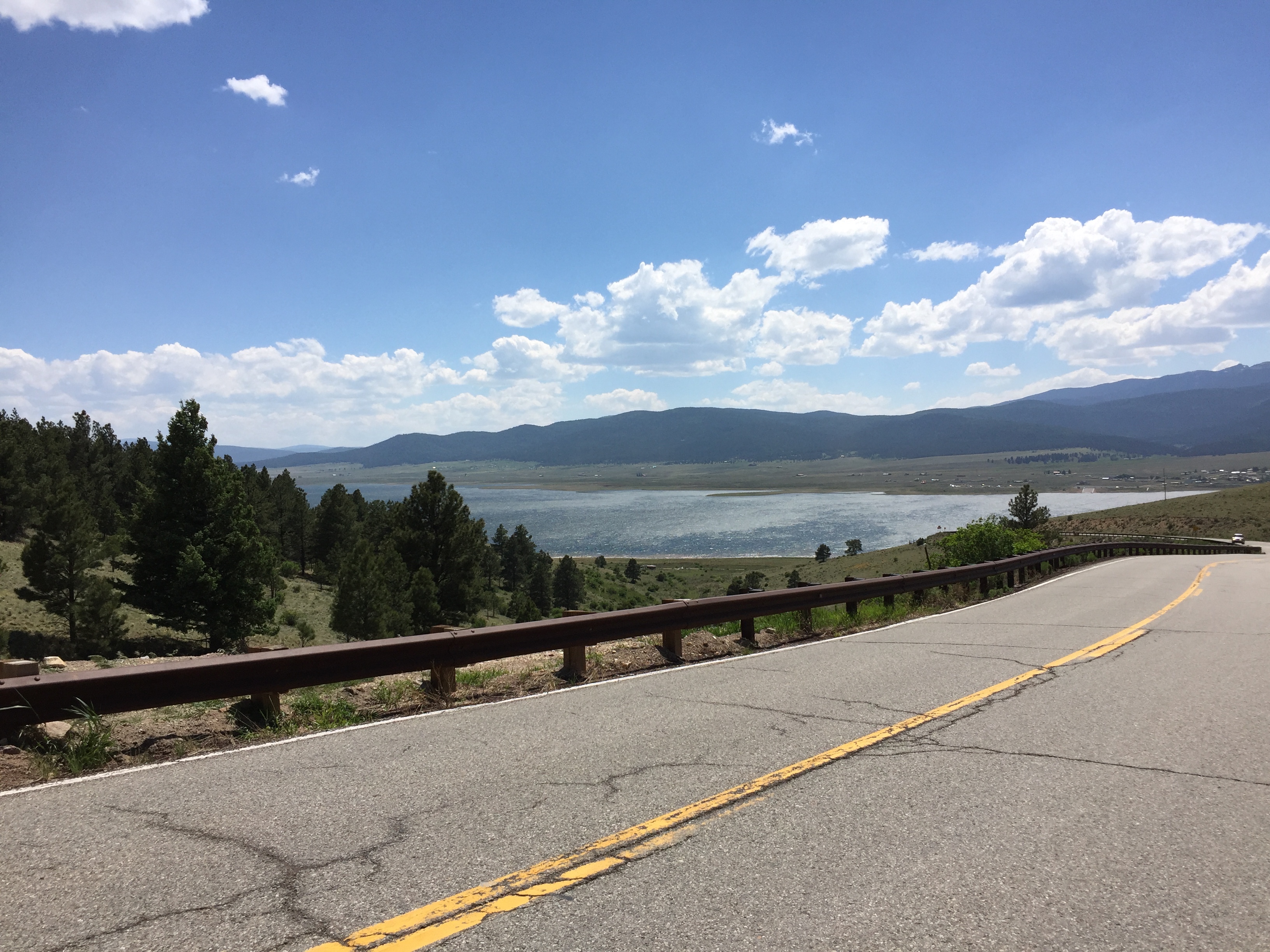
Eagle Nest, NM
The weather changed to perfect as I approached Cimarron, New Mexico and rode through Eagle Nest and Angel Fire on my way to Taos. The route I took, NM 58 and US 64, into Cimarron and the Enchanted Circle Scenic Byway was very beautiful and worthy of GoPro video and iPhone photos.
In the photo at the right, the road sign indicates that Eagle Nest is at an elevation of 8,258 feet above mean sea level. In the photo below, that's Eagle Nest Lake. Further south and a little further west along US 64, is Angel Fire, a popular downhill ski resort.
 Taos itself is gorgeous! I'm so glad my colleague Todd Plessel urged me to see it. It reminds me of Banff in that you see mountains from the main street in town. I wish my friend Mitch could have joined me to see it so he could also compare it to Banff.
Hotel La Fonda de Taos
 I loved my hotel, the LaFonda DeTaos. It's a bit pricey, but very very nice. The location is excellent and it offers private parking. It's located right in the town square. For you geography buffs, Taos is at an elevation of approximately 7,000 feet. My iPhone compass app lists my current location at 6,995 feet. (I've just finished dinner at Martyr's Steakhouse. It's a bit pricey but the food is excellent.) So, the peaks around it must be at least 9,000+ feet, e.g., Wheeler Peak at 13,161 feet. Wheeler is at the center of the Enchanted Circle Scenic Byway.
I finally started using my GoPro as I had intended, as I rode through Cimarron. The remote's battery was dead--even though I though I charged it last night--so I had to use my iPhone to control the camera. I also captured video on the Enchanted Circle.
I did not arrive at my hotel, the LaFonda de Taos, until 4:30 p.m. Mountain Time, or 5:30 p.m. CDST. It made for a very long day -- 11 hours. Consequently, I am not going to ride any more of the Enchanted Circle Scenic Byway, except what I shall ride in the morning on US 64 west.
More Videos
US 64 & Cimarron, NM Area
This series of videos shows my ride into the Enchanted Circle Scenic Byway area on US 64.
- US 64 & Cimarron, NM Area - 2 of 6: https://youtu.be/rENycqzIzT0
- US 64 & Cimarron, NM Area - 3 of 6: https://youtu.be/0Y7gg7XvIc8
- US 64 & Cimarron, NM Area - 4 of 6: https://youtu.be/nuDIC_mIKzQ
- US 64 & Cimarron, NM Area - 5 of 6: https://youtu.be/Ixt0iw91JSo
- US 64 & Cimarron, NM Area - 6 of 6: https://youtu.be/RciE6KdF9iE
- US 64 in Eagle Nest, NM: https://youtu.be/PSYUwcnOUsw
- Riding into Taos, NM and to the romantic Hotel La Fonda DeTaos right in the town square: https://youtu.be/btoFvwE7u_o
- Taos, NM Town Square: https://youtu.be/jxMu2Vy1jhw
Day 5: Taos, NM to St. George, Utah
Here I just want to insert a few more photos from the morning of Day 4, as I finished crossing New Mexico and headed into Arizona and Utah, on my way to my mother's home in St. George--with a quick stop at Four Corners. (In a separate post, I'll cover the afternoon of Day 5, which included the Navajo Nation in Arizona.)
Crossing the Rio Grande in Northern New Mexico - Three Videos
In this series of three videos, I’ve stopped just west of Taos for a look at the Rio Grande, which works its way south to Mexico.
- Crossing the Rio Grande in Northern New Mexico - 1 of 3: https://youtu.be/D7sqaSl5p5Y
- Crossing the Rio Grande in Northern New Mexico - 2 of 3: https://youtu.be/SN7WqI6hRlQ
- Crossing the Rio Grande in Northern New Mexico - 3 of 3: https://youtu.be/U6yIrvICboQ
Carson National Forest
US 64 in Carson National Forest took me to elevations over 10,000 feet and made for some chilly temperatures by great views.
Day 4 Mileage and Odometer Reading
My initial odometer reading was 12,385. The reading the night of Day 4 was 14,245. Daily mileage to date was as follows:
- Friday, June 10: Cary, NC to Hendersonville, NC (270 miles)
- Saturday, June 11: Hendersonville, NC to Marion, Arkansas (540 miles)
- Sunday, June 12: Marion, AR to El Reno, Oklahoma (520 miles)
- Monday, June 13: El Reno, OK to Taos, NM (530 miles)
(Tripometer reading was 1860.5.)